A Force for Good: How Digital Jedis are Responding to the Nepal Earthquake

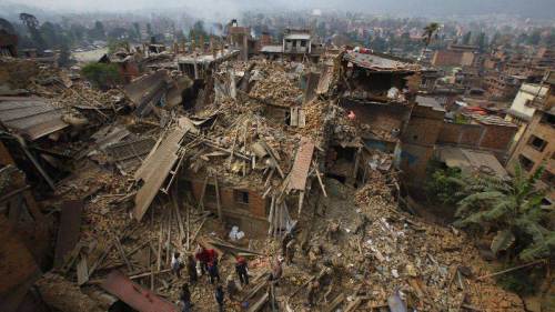
Digital Humanitarians are responding in full force to the devastating earthquake that struck Nepal. Information sharing and coordination is taking place online via CrisisMappers and on multiple dedicated Skype chats. The Standby Task Force (SBTF), Humanitarian OpenStreetMap (HOT) and others from the Digital Humanitarian Network (DHN) have also deployed in response to the tragedy. This blog post provides a quick summary of some of these digital humanitarian efforts along with what’s coming in terms of new deployments.
At the request of the UN Office for the Coordination of Humanitarian Affairs (OCHA), the SBTF is using QCRI’s MicroMappers platform to crowdsource the analysis of tweets and mainstream media (the latter via GDELT) to rapidly 1) assess disaster damage & needs; and 2) Identify where humanitarian groups are deploying (3W’s). The MicroMappers CrisisMaps are already live and publicly available below (simply click on the maps to open live version). Both Crisis Maps are being updated hourly (at times every 15 minutes).
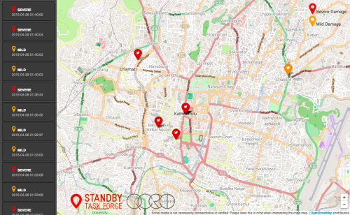
Live CrisisMap of pictures from both Twitter and Mainstream Media showing disaster damage:
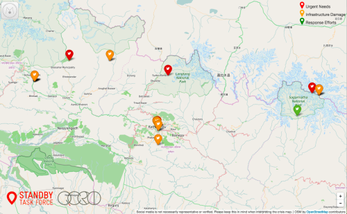
Live CrisisMap of Urgent Needs, Damage and Response Efforts posted on Twitter:
Note: the outstanding Kathmandu Living Labs (KLL) team have also launched an Ushahidi Crisis Map in collaboration with the Nepal Red Cross. We’ve already invited invited KLL to take all of the MicroMappers data and add it to their crisis map. Supporting local efforts is absolutely key.
The Humanitarian UAV Network (UAViators) has also been activated to identify, mobilize and coordinate UAV assets & teams. Several professional UAV teams are already on their way to Kathmandu. The UAV pilots will be producing high resolution nadir imagery, oblique imagery and 3D point clouds. UAViators will be pushing this imagery to both HOT and MicroMappers for rapid crowdsourced analysis (just like was done with the aerial imagery from Vanuatu post Cyclone Pam, more on that here). A leading UAV manufacturer is also donating several UAVs to UAViators for use in Nepal. These UAVs will be sent to KLL to support their efforts. In the meantime, DigitalGlobe, Planet Labs and SkyBox are each sharing their satellite imagery with CrisisMappers, HOT and others in the Digital Humanitarian Network.
There are several other efforts going on, so the above is certainly not a complete list but simply reflect those digital humanitarian efforts that I am involved in or most familiar with. If you know of other major efforts, then please feel free to post them in the comments section. Thank you. More on the state of the art in digital humanitarian action in my new book, Digital Humanitarians.
About the author:
Patrick Meier is an internationally recognized thought leader on humanitarian technology and innovation. Author (2015): "Digital Humanitarians: How Big Data is Changing Humanitarian Response." Previously: Harvard Humanitarian Initiative, United Nations, World Bank. Currently: QCRI. PhD from Fletcher School, Pre-Doctoral Fellow at Stanford and MA at Columbia. Born & raised in Africa.
This article was originally published at http://irevolution.net/2015/04/27/digital-jedis-nepal-earthquake/ and is republished here with Patrick Meier's and iRevolutions permission.
Recommended
-

-

AIDF are pleased to open nominations for the Africa Innovator of the Year Award 2019!
-

Just three countries support over 50% of the World’s refugees
-

-

-

UN report warns Asia-Pacific is falling behind Zero Hunger targets, as millions remain malnourished
-

WHO’s ‘World Malaria Report’ warns that global progress in eliminating the disease is stalling
-

Approximately 821 million people in 2017 suffered from hunger, according to new report
-

Every country in the world is falling short of malnutrition targets, warns new report
Subscribe To Our Newsletter
Subscribe