TerraMar Networks Limited
- Location:Unit 1Vale Business Park, Greysteel, Co. Londonderry BT47 3GE, N Ireland
- Telephone:0044 28 7181 1782
- Email:
- Website:
TerraMar Networks is a leading global provider of GPS vehicle and fleet tracking and GPS asset management solutions. Our expertise spans a variety of industry sectors, including logistics and haulage, commercial maritime and offshore oil and gas.
NGOs often operate a range of vehicle types, such as light trucks, 4×4 vehicles and motorcycles, across a variety of disparate locations around the world. Optimising fleet operations in this environment is a challenge – particularly given that dedicated logistics staff may be in short supply.
We offer intelligent solutions for humanitarian agencies, helping central, regional and field organisations to co-ordinate more effectively and run a more efficient, less costly, greener fleet.
We can provide satellite and dual mode (cellular & satellite) devices, together with a range of applications, designed to help manage vehicles and personnel, wherever they are.
Products and Services
tracpoint is our comprehensive, web-based tracking application. It's been designed to work with a variety of hardware and communications networks, so that it supports a wide range of applications on land, at sea and in teh air.
Features include:
High quality real time mapping
Historic mapping and route replay
A wide range of performance reports
Geofencing and landmarks
Alerts and alarms, delivering by email and SMS
Great sustomer service, including training and after-sales support
-
Hardware
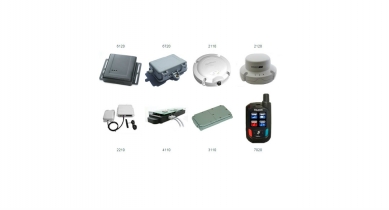
tracpoint supports a wide range of hardware, including the examples listed here. Others can be added on request.
- trac 6120 - General purpose tracking device (GSM)
- trac 6720 - Robust, weatherproof device (GSM)
- trac 2110 - Satellite device - (land Inmarsat)
- trac 2120 - Satellite device - marine (Inmarsat)
- trac 2210 - Hybrid device (Inmarsat/GSM)
- trac 4110 - Satellite devioce (Iridium)
- trac 3110 - Satellite device (Globalstar)
- trac 7020 - Personal tracking device (GSM)
-
Networks
tracpoint supports a wide range of hardware, including the examples listed here. Others can be added on request.
GSM cellular
GSM networks provide reliable and affordable data transfer. We can provide a Global M2M SIM card which will roam onto nearly any GSM network worldwide.
Geostationary Satellite (Inmarsat C / Isat M2M / Isat DataPro)
For remote areas such as the oceans, deserts and sparsely populated of the globe, Inmarsat data networks provide a suitable tradeoff between coverage and cost.
Low Earth Orbit Satellite (Globalstar / Iridium)
LEO satellite networks are compatible with hardware which is smaller, lighter and requires less power than Inmarsat. For a number of mobile applications in remote areas, they prove to be the best choice.
AIS (Terrestrial)
Shore-based terrestrial AIS networks can provide a valuable overview of movements around coastal areas and in ports.
AIS (Satellite)
Satellite AIS offers global coverage of maritime traffic.
